|

|
|
|
|
History of Markham Village
86 Peter St, Markham, Ontario L3P-2A6
Markham Township was originally surveyed in
1793-1794 and was named after Archbishop William Markham of York, England
by John Graves Simcoe, the Lieutenant-governor of Upper Canada. William
Markham never visited his namesake.
As people settled in the township in the early
east corner of Hwy.48 and 7 (Lot 11, Conc.8) was sold to Joseph Reesor,
one of a large number of Pennsylvania-Germans who were to make this area
their home. A few years later, several homes stood on his corner. This
small community was known as Reesorville. Later, it was referred to as
Mannheim (German for ‘man’s home’). by 1828, when the post office (53 Main
St. S.) opened, the hamlet adopted the township’s title, Markham.
The industry in the early village was nestled on
the banks of the Rouge River which crosses Hwy. 48 south of Hwy 7. The
water was harnessed to power the machinery of the saw, grist and woolen
mills which were located on the riverbanks.
In addition to mills, taverns also made an early
appearance. Inns were necessary at this time of slow travel. Here , weary
travellers were assured a satisfying repast and a place to rest.
Mills and hotel required the services of coopers
(barrel-makers) and distillers and so, these subsidiary businesses
established themselves nearby. the mills and taverns also attracted local
people and travellers. Consequently, storekeepers, blacksmiths and other
businessmen set up shop to service the same customers. Gradually, the
business activity of Markham Village spread northward from Vinegar Dip.
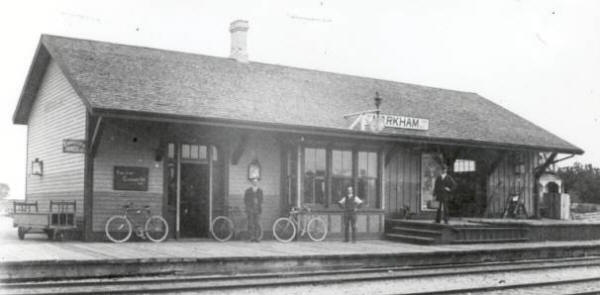
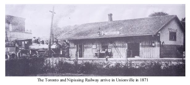
the opening of the Toronto and Nipissing Railway through the village in
1871 pulled Markham’s manufacturers and tradesman further north. Before
the turn of the century, there was so much manufacturing being done in the
village that Markham became known as the ‘Birmingham of Ontario’.
In 1872, the Village of Markham was incorporated.
In May of this year, a fire had destroyed a number of buildings on Main
Street. as a result many felt that if the village was to be protected from
fire and other necessary improvements were to be made, then, everyone
should be taxed. To do so the village had to be incorporated. Nine years
after incorporation, the village of Markham boasted 954 residents.
The Vinegar Hill story
Main Street Markham Village south of Highway 7 is
known as Vinegar Hill. Long-time resident of Princess Street, Myra Chepak,
has provided the following history of how Vinegar Hill came by its name.
There are two versions of how this name came about.
The first, as told to Alma Walker, former Reeve of
Markham Village, by the late John Lunau, who was considered the Historian
of Markham, credits a local Irish family named Baker with calling the area
for their home in Ireland.
The second version is much more colourful and was
related to the same Mrs. Walker by Mort Selleck, the local gravedigger,
who was an old duffer, sixty years ago, when the story was told. He
carefully and colourfully described how on Good Friday and only on Good
Friday, the coopers (barrel makers) held a competition.
Now keep in mind the area did not look as it does
today. Princess Street jogged off to the north-west from the tree lined,
dirt road now known as Highway 48 and curved back north of the Rouge
River. Fisher Court remains as a reminder of where the roads re-joined,
after the last bridge was washed out in 1954 by Hurricane Hazel. A woolen
mill was located to the west of the river owned and operated by the Milne
family and a grist mill operated in the valley land area east of the
Rougehaven development.
It was the barrel makers of these two mills that
instigated the competition. They each filled barrels with vinegar and
rolled them from a point just south of Mill Street, down the steep, dirt
track to determine whose barrels would run in the straightest line,
thereby crediting one or the other with building the truest and best
barrel. Thus, the name Vinegar Hill!
|
|
History of
Markham, Ontario, Canada
| About 1000 AD, Markham
was first settled by the Iroquois people who lived in
semi-permanent villages, growing mainly corn, but also
squash, beans and sunflowers, in the fertile soil they
found in the valley of the river they called the
Katabokakonk, “river of easy entrance”. They also used the
river and valley as a route to the north country. In the
17th century, five aboriginal tribes, speaking
related languages—the Mohawk, Seneca, Cayuga, Onondaga and
Oneida peoples---formed a federation called the Five
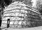
Iroquois Nations.* The distinctive structure built by the
Iroquois was the “longhouse”, a grouping of these
multi-family dwellings making up an Iroquois settlement.
|
|
|
|
In 1608, the
French founded a colony in Quebec City and, from there,
established settlements along the shores of the St. Lawrence
River. They began to explore further inland and laid claim to the
lands where Markham now stands. When they visited this area they
found the Katabokakonk river but, struck by how in places its
waters were coloured reddish by the clay along its banks, they
named it the Rivière Rouge. During these explorations, the French
also pursued the fur trade with the native peoples. In the middle
of the 17th century, there existed a village near the
mouth of the Rouge River called Ganatsekwyagon, inhabited by
Senecas, one of the five nations of the Iroquois confederacy. It
was eventually abandoned but the discovery of relics at a location
about a kilometre up the eastern bank of the Rouge from Lake
Ontario has lead to the belief that it is the site of the village
of Ganatsekwyagon.
With
Britain’s victory in the Seven Years War with France (1756-1763),
the French King ceded his colony of New France to Britain. This
included the territory north of Lake Ontario and Lake Erie.
Britain now had to decide how to organize this new territory. She
created a province which she called Quebec and which extended to
just west of the Ottawa River. The territory to the west of that
line, including, of course, where Markham stands today, was
designated as Indian Territories. At first, new settlement was
excluded from this area and trade with the native peoples could be
carried on only under license. Treaties were negotiated with the
aboriginal peoples.
In those
years Britain was still in possession of her American colonies
located along the eastern seaboard of the Atlantic.
English-speaking peoples began to trickle into her new northern
colony, principally to Montreal or east. A decade after obtaining
New France, however, the difficulties for Britain of ruling a
population that was still predominantly French-speaking and Roman
Catholic resulted in her proclaiming the Quebec Act of 1774. This
Act recognized the Roman Catholic religion, and provided that in
this territory the French Civil Code would apply to civil matters,
such as property, marriage and inheritance but that in criminal
matters the British criminal code would apply. The Act also
extended the boundaries of the territory called the “Province of
Quebec” westward to include where Markham stands today. It even
extended the boundary south to the Ohio River and west to the
Mississippi.
The Quebec
Act satisfied the French population but angered the recent British
arrivals who found themselves subject to laws which they viewed as
foreign. It also angered Britain’s American colonies who coveted
the lands that Britain had just included in the new boundaries of
the Quebec territory. The anger that the American colonists felt
further fuelled the already existing grievances that led to the
outbreak of the American war of independence in 1776.
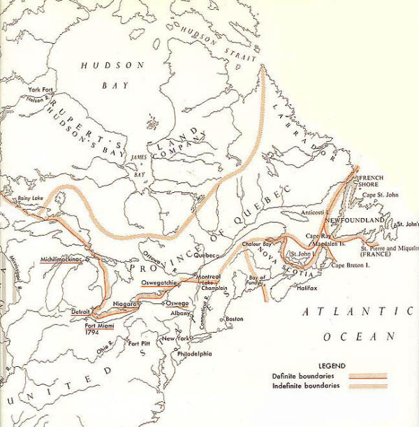
In 1783,
Britain had to recognize the independence of the new United States
of America and from that year the western boundary between this
new country and Britain’s Province of Quebec was a line running
down the middle of Lake Ontario, Lake Erie, Lake Huron and Lake
Superior (see map below).
The
American revolutionary war provoked a new immigration north into
British territory on the part of the United Empire loyalists,
Americans who left the fledgling United States to remain loyal to
Britain. Among them were also some German soldiers from among the
foreign troops that had been hired by Britain and brought over to
reinforce its forces fighting in the war. In 1787, with Loyalist
settlements now established in Niagara and others in Cataraqui
(near Kingston) Governor Dorchester negotiated a treaty with the
Mississauga aboriginal nation in which the Crown purchased a tract
of land, called the “Toronto Purchase”, which made it possible to
connect these two settlements.
The
arrival of the Loyalists, many of whom settled in the western part
of the Quebec territory, led the British Parliament in 1791 to
pass the Constitutional Act that divided this territory into two
provinces, the eastern province to be called Lower Canada
(corresponding to the southern part of what is now the Canadian
province of Quebec), and the western part to be called Upper
Canada (corresponding to the southern part of what is now called
the province of Ontario). In Lower Canada, the French Civil Code
would continue to apply, but in Upper Canada the British Common
Law would now apply to civil matters. Each province was to have
its own Lieutenant-Governor appointed by Great Britain, an elected
Legislative Assembly, and an upper house called the Legislative
Council whose members would be appointed by the
Lieutenant-Governor.
|
|
The
creation of the province of Upper Canada made it possible
for the settlement and development of our area to really
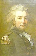
take off. The first
Lieutenant-Governor of Upper Canada was John Graves
Simcoe. During his term as Lieutenant-Governor, Simcoe
took many steps which impacted directly on Markham. The
first capital of Upper Canada was Niagara-on-the-Lake
(then called Newark) but, located just across the Niagara
River from the United States, it was judged too vulnerable
to attack from the new American republic. Simcoe decided
to move the capital to York (now called Toronto).
For
administrative purposes, Simcoe divided the province into
four districts which he named Eastern, Midland, Western
and Home. The districts were divided into counties, and
the counties eventually into townships. The Home District
contained the provincial capital, York, located within the
wider county which was also named York.
|
|
|
|
John Graves Simcoe
|
|
One of
Governor Simcoe’s greatest concerns was for the military security
of Upper Canada. The clearing of Yonge Street fit partly into this
strategy. Increasing the population by attracting new immigrants
through a system of free land grants was another important
element. The southern part of York was organized and surveyed into
farm lots by 1792. From 1793 to 1794 the same work was completed
in the township of Markham. Simcoe named the township after his
friend William Markham, the Archbishop of York (England) at the
time.
An
explanation of the system by which Markham township was divided
into lots gives us some clues to the emergence of the streets and
roads whose names are so familiar to us now. The township,
rectangular in shape, extended from Yonge Street to the Pickering
Town Line and was divided, from west to east, into ten sections,
called concessions, each one 1 ¼ miles in width. These concessions
were bounded on the south by the Scarborough Town Line (now called
Steeles Avenue) and on the north by the Whitchurch Town Line. They
were crossed by a grid of six sideroads, running east and west,
which were also 1 ¼ miles apart. The land was divided into 200
acre lots, running, long and narrow, from one concession road to
the next. On the north-south plane, five lots were created between
every two sideroads. The road we now call Highway 7 was originally
called sideroad 7 in Markham Township. The side road north of it
is now called 16th Avenue.
Some modern-day roads, however, still retain their original names
from the 1793-94 survey. For example, the 9th Line, on which is
situated the new community of Cornell, continues to be the name
used for an important north-south road in the eastern part of
Markham.
|
|
This survey
included the allocation of one seventh of the lots to be reserved
to support a Protestant clergy. These were called clergy reserves.
Another seventh of the lots were reserved for the disposition of
the Crown, in other words, of the Lieutenant-Governor’s
government. The fact that the Lieutenant-Governor could dispose of
these lands as he wished meant that he could raise money without
having to ask for the approval of the new local assembly. Remember
that the Lieutenant-Governor of that time had real power, which
came, not from the electorate, but from the powers conferred on
him by the Imperial Government in London, and he resented, and
avoided when he could, any constraints that an elected assembly
could put on him. The Crown reserves eventually were all sold by
1828 but the clergy reserves continued to be a source of friction,
and even contributed to the grievances which led to the rebellion
of 1837. They were not sold off until 1854.
But let’s
return to the years immediately following the creation of Upper
Canada and the surveying of the new townships. European settlement
in Markham began with William Moll Berczy. He was a German
entrepreneur and artist who in 1792 led a group of German settlers
to the United States with the intention of settling in the Genesee
Tract in upper New York State. After
their arrival in New York, however, problems arose over land
tenure and there were disputes over finances. The Berczy settlers
began to look elsewhere. In May of 1794, Berczy negotiated with
Simcoe for 64,000 acres in Markham Township, soon to be known as
the German Company Lands. The Berczy settlers, joined by several
Pennsylvania German families, set out for Upper Canada that same
year.
|
|
Approximately a hundred and ninety arrived. The double
trials of harsh winters and crop failures made their first
few years difficult and a number of settlers moved back to
Niagara, their first point of entry into Upper Canada.
Those who stayed were to eventually prosper. Some of the
Berczy settlers, using the Don River, moved their
equipment and provisions to lot 4 in Concession 3 where
they founded a small hamlet, complete with a grist mill
for the grinding of grain, that came to be called German
Mills.
|
|
|
|
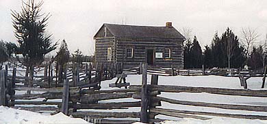
Early settler's log cabin
preserved at the Markham Museum
|
|
|
|
Another group of émigrés were
French aristocrats who had fled to Great Britain to escape the
upheavals of the French Revolution. They became a burden on the
British government who, as a result, arranged for their
immigration to Upper Canada. Lots were set aside for them on both
sides of Yonge Street north of what later was called Elgin Mills
and in 1799 they arrived. This was not a group well suited to the
rigours and the isolation of what was still a remote area and
eventually most of them sold their holdings to one of their group
who had been more successful, Laurent Quetton St.
A very important immigration
also came from the Pennsylvian German communities of the United
States. Sometimes referred to as the Pennsylvania Dutch (partly
due to an erroneous anglicization of Pennsylvania Deutsch) these
people had lived in Britain’s American colonies for a century,
their ancestors having left Europe to escape religious
persecution. But now, faced with a shortage of land for their
large families, and unwilling to swear allegiance to the new
Republic, some looked to the British territory to the north for
new possibilities. One of the members of this community who came
to the Markham area to look into land acquisition was Peter
Reesor. He returned to Pennsylvania and then, along with other
families, came back in the trek of 1804. These new settlers were
able to purchase land at good prices. A hamlet grew up near their
settlements that was first called Reesorville, and later Markham
village. Unlike the Berczy settlers before them, they did not
receive their land as a grant. Because of their long experience in
farming in Pennsylvania, these settlers, most of them of the
Mennonite religion, adapted easily to their new country.
Although there was some
immigration that came directly from Britain, emigration to Canada
via the United States was the main source of new settlers for the
first several years of the life of Upper Canada, and of Markham in
particular.
What kind of administration was
in place at that time? The four districts created by
Lieutenant-Governor Simcoe were the basic units. In the Home
District, as it was with the other three, the management of local
affairs was placed in the hands of magistrates who were appointed
by the Lieutenant Governor. The magistrates were responsible for
all local expenditures such as paying the fees for parish clerks
and jailers, appointing township and district constables,
surveyors, and inspectors of weights and measures. They also
regulated markets, built and managed courthouses, jails and
asylums. Anyone who wanted a license to sell liquor had to apply
to the magistrates. The only ministers who could perform marriages
were those of the Anglican, Presbyterian and Lutheran churches who
had been licensed by a magistrate to do so.
The district magistrates were
required to hold a yearly town meeting at which local officers
would be elected. A town meeting in the Home District on July 17,
1797 records, among other appointments, the naming of William
Berczy as Overseer of Highways for the German Settlement and John
Stamm as its Constable.
In 1812, Upper and Lower Canada
were in crisis as war broke out between Britain and the United
States. This was mainly the result of trans-Atlantic issues
between the two countries but, as the two Canadas were British
possessions, the United States attacked Britain through her North
American territories. Land invasions by the American forces near
Detroit and Niagara were both repulsed by a combination of British
regular forces, locally raised militias (in which some Markham
residents fought) and aboriginal fighters that rallied to the
British side.
These militias had come into
existence due to the Militia Act, a law that Simcoe had put
through the Parliament of Upper Canada back in 1793. This Act
required all males between the ages of 16 and 50 years, who were
residents of Upper Canada and who were physically fit, to be
enrolled in local militia companies. These units had to muster and
be inspected twice a year. One unit of the local militia was
called the York Militia, in which John Button, from the 4th
Concession Line of Markham, held the rank of Captain. Captain
Button was the first of three generations of his family to serve
in the Canadian militias, being followed by Francis Button and
William Button. Benjamin Milliken, after whom one of Markham’s
oldest communities is named, served as a private in the York
Militias. In 1813, American forces, backed by guns from naval
ships offshore, landed near Sunnyside beach, and occupied the town
of York for five days during which they burned the Parliament
Buildings and Governor’s residence and sacked many private homes
that had been abandoned by fleeing residents. Peace between
Britain and the United States was restored in 1814.
At the end of the Napoleonic
wars, of which the war of 1812-14, was a side effect, Britain
found herself with a large number of demobilized soldiers. Many
were attracted by the news of cheap land in Canada. A number of
ex-officers bought land along Yonge Street, while some of the
soldiers became pioneers, buying less expensive land further into
the township. Benjamin Thorne was one of these new settlers,
operating a mill in a spot that was called Thorne’s Hill, later
abbreviated by the Post Office to Thornhill.
During these
early years of Markham’s history, when pioneering, and its rigors,
played the main role, there began also the development of
agricultural industries. The township’s many rivers and streams
soon supported water-powered saw, grist and woollen mills. In
fact, because of the poor roads, it was the presence of a local
mill that was usually the spur to the development of the first
small hamlets. German Mills, Almira, Buttonville (named after the
family that took a leading role in the militias) and Cedar Grove
are examples of small hamlets that developed around a mill site.
Another of these hamlets, originally part of the Berczy
settlement, grew up at the 6th Concession Line just
north of the Rouge River, and took the name of Unionville after
the re-uniting of Upper and Lower Canada in 1841.
What were the
events that led back to union? The Constitution Act of 1791, that
created the separate provinces of Upper and Lower Canada and
established the system of government that would prevail in each,
led to the rapid development of Upper Canada but it also contained
the seeds that grew into discontent and eventual rebellion. The
problem arose in that under the colonial governing structure the
Lieutenant-Governor was accountable mainly to the Imperial
Government in London, rather than to the elected assembly. He
could appoint whomever he wanted to public positions, including to
the powerful Upper House of Parliament, the Legislative Council. A
small circle composed of the Lieutenant-Governor, the members of
the Legislative Council and a small number of established families
came to form a governing clique over whom the people could not
exercise control. This small but dominant group was dubbed The
Family Compact by William Lyon Mackenzie, the main spokesman for
those advocating a reform of the political system. The reformers
called for “responsible government”, a government that was
responsible, or answerable, to the elected legislature.
The people of
Markham were typical of the province’s population in that they
were politically aware and the bitter disagreements between the
reformers led by Mackenzie and the citizens who supported the
Lieutenant-Governor created deep divisions. As part of the riding
of York, Markham elected MacKenzie as their member of the
Legislative Assembly on five occasions between 1828 and 1836 but
he was always expelled soon after. Many felt sympathy with his
demands for responsible government. But many of these sympathizers
also continued to feel loyalty to the Crown. Mackenzie, however,
went beyond and began to adopt openly republican views.
|
| In 1837
armed rebellions broke out in both Upper and Lower Canada.
In Lower Canada, where the same grievances were fanned by
a French-Canadian national feeling pitted against a
British-dominated colonial regime, the uprising dragged on
into the following year. In Upper Canada, the revolt led
by William Lyon Mackenzie, was quickly put down.
Mackenzie’s republican views had alienated some who could
have been his supporters. He was also no military
strategist. However some Markham farmers did answer the
call to open rebellion, as a result, many faced arrest.
Other Markham citizens opposed the rebellion. Captain John
Button raised armed troops of militia to help to quash the
uprising. |
|
|
|
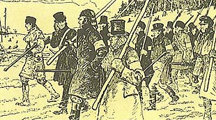
Mackenzie's rebels marching down
Yonge Street
as depicted by historical artist C. W. Jeffreys
|
|
|
|
Although the
rebellions in Upper and Lower Canada were both defeated
militarily, they did result in a major change to the way the two
provinces were governed. The British Government sent Lord Durham
to conduct an enquiry into the causes of the unrest. He
recommended that Upper and Lower Canada be reunited under a single
government which would be answerable to a single elected assembly.
He also recommended that the principal of Responsible Government
be granted to this united province. What that meant was that under
the new constitution, the Governor, in all matters internal to the
province, could no longer act unilaterally, but would conduct
himself in the same way as the Queen did in the home country. That
is, he would govern on the advice of his elected ministers, and
his ministers had to enjoy the confidence of the elected assembly.
This is the principle by which we are governed today. One could
say that, through the granting of this principle in 1841, Britain
ceased to govern her colony of Canada as far as the purely
internal affairs of the province were concerned. This united
province, however, did not become a sovereign country. Our
relations with other countries were still the exclusive
responsibility of the Imperial Government in London as was, to a
large extent, our defence.
Under the old
constitution, and the new, electoral politics remained a rough
affair. Voters had to travel long distances, and at the polling
locations they voted verbally. There were often attempts made to
intimidate voters. Free liquor was offered in the taverns during
election week.
Drinking was
itself an issue much debated in those times. Because of the
difficulty of transporting grain, local breweries sprang up in
many communities. For innkeepers, the sale of liquor was the basis
of their livelihood. At harvesting, barn raisings—and other tasks
where many pitched in---alcoholic drinks were generally expected
to be provided. As the years passed, the temperance movement
gathered strength in response to this and the contention between
the two sides was ongoing.
The
new system of responsible government also greatly reduced the
privileged position of the Church of England, or Anglicans. Under
the previous regime, centred as it was around the British
appointed Lieutenant-Governor, the Anglicans had been favoured.
The clergy reserves set aside in the land survey had been for
their benefit. Until 1831 the only Protestant denominations
allowed to perform marriages were, most importantly, the
Anglicans, and, in addition, Lutherans and Quakers. Some smaller
and newer sects, such as the Methodists, were starting, however,
to gain followers. The Methodists were distinguished by their use
of the itinerant preacher, who rode on horseback, or, in winter,
by sleigh, to visit believers.
Another
change that came as a result of responsible government was that
more public money was invested in education. In Markham’s early
years, with the arrival of the Berczy settlers and the
Pennsylvania Germans, Markham as a community had a distinctly
German character. Many of the schools in those communities used
German as the language of instruction. Later, in 1844, Dr. Egerton
Ryerson was appointed to organize the school system in Canada
West, the western half of the United Province of Canada. Starting
in 1849, municipal councils could levy taxes specifically for
school purposes and Markham Township appointed Anglican Rev.
George Hill as its first supervisor of schools. The most common in
those days was the one room elementary school, in which one
teacher taught all the grades. By 1870, all school expenses were
paid through taxation and school attendance was compulsory for
children aged 7 through 13. They had to attend school at least 100
days every year.
The
Municipal Corporations Act of 1849 affected more than just the
school system. It went a long way toward bringing our system of
local government closer to what we experience today. In 1841 the
old District town meeting had been abolished and replaced by an
elected District Council but this proved to be only an interim
stage. The 1849 Act abolished the District system completely and
established municipal governments to replace it. The county became
the unit of organization, and county and township councils were
established. In 1850 by-laws were passed by which the Township of
Markham would be regulated and in 1851 David Reesor was elected
Reeve. Henry Miller became deputy Reeve and there were three
Councillors.
|
|
In
Markham, by the middle of the century, most of the
township had been cleared of forest and much of the land
was under cultivation. But maintaining the concession
lines and side roads was always a challenge. Most of the
work was done by statute labour. The farm owners were
obligated, according to their assessment, to provide a
certain number of days of work on the roads, including the
supplying of a team of horses and a wagon. One early
method of dealing with swampy ground was the laying of
tree trunks side by side. Earth was dug from the side of
the road and laid on top of the logs. This also produced a
ditch on each side. However, with rains and floods, the
earth covering was washed away and these so-called
“corduroy” roads became bone jarringly bumpy. Paving the
main roads by laying successive layers of broken stone
(this was called macadamizing) proved too costly, with the
result that they were planked instead. That, however, was
not an ideal solution either as the planks heaved, broke
or wore out and needed to be replaced every eight years.
In 1864 gravelling was adopted as a means of maintaining
some of the main concession lines and side roads. Over
time, the population increased and villages like
Thornhill, Unionville and Markham greatly expanded.
Specialised industries began to spring up, such as wagon
works, tanneries, farm implement manufacturers and
furniture factories.
|
|
|
|
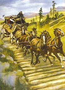
corduroy road
|
|
|
|
The road that
was critical to the development of all the communities along its
path was Yonge Street. When Lieutenant-Governor Simcoe decided on
Toronto as the navel arsenal of Lake Ontario, he looked for the
most direct route north from Toronto to Georgian Bay and Lake
Huron. He decided that following the old Indian trail to Lake
Simcoe, and then using the system of rivers and portages from
there, was the best route. Surveying of this road began in 1794
and the road was named Yonge Street by Gov. Simcoe after Sir
George Yonge who was then the Imperial Secretary of War. The
cutting out of the road to Lake Simcoe was completed in 1796.
William Berczy helped with the work on the road, starting at
Eglinton, by sending a crew of men from the Berczy settlement. As
the years passed, the road was used by settlers, fur traders, and
also by detachments of soldiers making their way to the military
base at Penetanguishene on Georgian Bay. The road was surveyed
into farm lots on both sides from Eglinton to Holland Landing,
traversing several townships, including the Township of Markham.
Settlers along Yonge Street, as elsewhere, had to clear ten acres
for cultivation and fence it, build a house 16 by 20 feet, and cut
down all trees on the front of the lot. As the use of the road
increased, inns began to be established, and some small companies
providing transit, by horse drawn coach, began to operate along
Yonge Street.
|
|
In
1867, Canada’s constitution changed again. We mustn’t
forget that until that year the term Canada applied only
to the territory on both sides of the St. Lawrence River
and to the north of Lake Ontario and Lake Erie. In 1864,
Canada began negotiations with the British colonies in the
Maritimes and, after three years of talks, came to an
agreement with New Brunswick and Nova Scotia to form a
federal union, each retaining a provincial government and
elected assembly, and with a federal capital and
parliament located in Ottawa. This was called
Confederation. The new larger entity would also be called
Canada and its first prime minister was Sir John A.
Macdonald. The terms of the union also involved dividing
the old province of Canada into two again, one called
Quebec, and the other Ontario, each also with its own
provincial government responsible to a locally elected
assembly. But this new, and bigger, Canada was still a
colony within the British Empire. We had internal
self-government and Britain expected us to be responsible
for forming a militia for our own defence but Britain
maintained a navy base at Halifax and still handled our
relations with other countries.
|
|
|
|
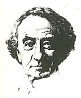
Sir John A. Macdonald
|
|
|
|
Toronto
became the provincial capital of Ontario. Railways had already
made their first appearance in 1853 with the inauguration of the
Ontario Simcoe and Huron Railway. The development of railways in
neighbouring townships posed a challenge to Markham’s own
prosperity, so local business owners began to look for allies who
could form a railway. On September 14, 1871, the Toronto and
Nipissing Railway Company, with stations in Unionville, Markham
and Stouffville, officially opened its Scarborough-Uxbridge line.
 At
first the railway brought renewed prosperity and rapid
development. Increased communication with Toronto, however,
brought about many changes. In 1896 the Metropolitan Radial
Railway was opened up. This made travel from Toronto to the
northern communities along the Yonge Street corridor much easier
and the era of coaches and inns eventually came to a close. An
interesting footnote to the impact of the new Radial Railway was
that some artists who later became members or supporters of the
Group of Seven moved from downtown Toronto and came to live in
Thornhill, or to visit it frequently. One member of this group was
J.E.H. MacDonald. Added to the railway links were also improved
connections through telegraph and telephone, all of which
eventually diminished the industrial role of the villages in the
Township of Markham after the turn of the century. At
first the railway brought renewed prosperity and rapid
development. Increased communication with Toronto, however,
brought about many changes. In 1896 the Metropolitan Radial
Railway was opened up. This made travel from Toronto to the
northern communities along the Yonge Street corridor much easier
and the era of coaches and inns eventually came to a close. An
interesting footnote to the impact of the new Radial Railway was
that some artists who later became members or supporters of the
Group of Seven moved from downtown Toronto and came to live in
Thornhill, or to visit it frequently. One member of this group was
J.E.H. MacDonald. Added to the railway links were also improved
connections through telegraph and telephone, all of which
eventually diminished the industrial role of the villages in the
Township of Markham after the turn of the century.
Most
of the communities within the Township of Markham looked to the
Township Council for local services. However some villages grew to
a size that entitled them to seek incorporation, giving them more
local authority. In the old Ontario system of municipal
government, there were police villages, villages, towns and
cities. When a population of at least 750 was found within an area
of 500 acres, it could apply to be incorporated as a village, a
status that gave it some measure of self-government. A smaller
population gathered in one centre could be organized as a police
village having less local authority than a village. When a village
attained a population of 2,000 persons it could be incorporated as
a town with larger powers. Finally when a town reached a
population of 15,000 it could be incorporated as a city with still
more extensive powers.
Markham
Village, its growth further spurred by the opening of the Toronto
and Nipissing Railway in 1871, was incorporated as a village in
1873. By 1900 it had a population of 950 people and boasted an
impressive new Town Hall. Just to the north, the community of
Mount Joy became a police village in 1907 but in 1915 was annexed
to Markham Village. Unionville was another of the stops of the
Toronto and Nipissing Railway. This contributed to the growth of
the community and in 1907 Unionville attained the status of police
village.
The
growth of centres of population did not always strictly follow the
township boundary lines and three villages in particular grew up
that straddled the lines between two townships. In the northeast,
Stouffville was located along the border between Markham and
Whitchurch townships. Like Unionville and Markham villages, it lay
along the route of the Toronto and Nipissing Railway but being
more distant from Toronto, it developed more independently and in
1873 was incorporated as a village. Along Yonge Street two
villages grew up whose developments were greatly linked with this
important road. Thornhill expanded, with its eastern part in
Markham Township and western part in Vaughan. It attained status
as a police village in 1931. This led to arrangements such as
having its fire protection provided by the two townships but paid
for by the village. Further north, Richmond Hill also straddled
Yonge Street, and thus also lay within both Markham and Vaughan
townships. It was incorporated as a village in 1872.
The advent of
the automobile, following the arrival of the railways, went
further in making it difficult for local
industries to compete with the larger factories
in Toronto. As a result, Markham Township, which had once been
called the Birmingham of Canada, slowly returned to its old
identity as a quietly productive agricultural community.
|
|
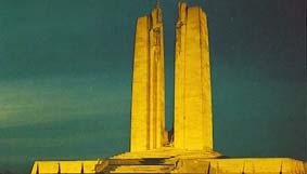
The
outbreak of World War I in 1914 and Canada’s participation
in the war effort spurred Canada’s evolution toward full
sovereignty. As a member of the British Empire, Canada was
automatically at war when Britain declared war on Germany
and Austria. Canadian soldiers, under ultimate British
command, fought in many key battles. One of them was
fought at Vimy Ridge, France in 1917. The 90th anniversary
of this battle was recently commemorated. When the war was
over the feeling had grown among Canadians that it was
time for them to decide for themselves what their
relationship with the rest of the world would be.
Canadians did not wish any longer to be automatically at
war when Britain was at war. Canada took on responsibility
for its own diplomacy and in so doing assumed status as a
fully sovereign country.
|
|
|
|
Vimy Ridge Monument
at Vimy, France
|
|
|
The war also
had an impact on the life of Markham. Still mainly agricultural,
Markham was affected by the departure of many of her young people
to fight in Europe. The shortage of labour stimulated further the
trend toward mechanization on the farm. The development of farm
machinery such as the grain combine meant that communal tasks,
such as the threshing of grain, were no longer necessary.
After World
War II (1939 – 1945), however, Markham began to feel the effects
of urban expansion from Toronto. Heavily industrialised by the war
effort and experiencing a post-war baby boom, the population of
the township grew. Markham Township celebrated its centennial as a
municipality in 1950 and rapid change was in store. It became the
destination for waves of new immigrants from all over the world,
but especially from people from the war ravaged countries of
Europe.
In 1971, the
modern Town of Markham was created, a single town now absorbing
the former villages of Unionville and Markham and most of the
territory of the old Township of Markham. But the new town did not
correspond exactly to the old Township rectangle. Some of the
western part was annexed to the new Town of Richmond Hill and the
northern boundary was moved south to a line between 19th
Avenue and Stouffville Road, leaving the village of Stouffville
entirely in the new Town of Whitchurch-Stouffville. The Police
Village of Thornhill was dissolved and this community was split
along Yonge Street between the Town of Markham and the City of
Vaughan. The citizens of the new Town of Markham now elect a
Mayor, and a Town Council made up of Councillors from the eight
town wards and four Regional Councillors.
What
are the duties of a “Regional Councillor”?. The reorganization of
1971 also created the Regional Municipality of York, made up of
the city of Vaughan, the towns of Markham, Richmond Hill,
Whitchurch-Stouffville, Newmarket, Aurora, East Gwillimbury and
Georgina, and the township of King. This municipal federation
provides services that are best provided across the entire region
rather than by each town on its own. These include a police force,
a regional public transit system and a common school board. Thus,
Markham voters, in addition to the eight Town Councillors, also
elect four Regional Councillors who, along with the Mayor,
represent Markham on York Regional Council which has its seat in
Newmarket. Markham’s four Regional Councillors also sit on
Markham’s own Town Council.
The opening
of Highway 404 in the mid-1970s further accelerated the urban
development of the town. Markham has attracted many companies of
the high technology sector and now styles itself the “High Tech
Capital of Canada”.
The
growth of the population along with the arrival of new industries
has resulted in large acres of farmland being turned to
subdivisions and industrial areas. Markham now increasingly
confronts the often conflicting needs of urbanization and
preservation of natural spaces.
Since its
very beginnings, Markham’s progress has been stimulated by
immigration and the city has in recent years attracted a new,
dynamic and multicultural population with roots in every
continent. Especially significant in the last quarter century has
been immigration from Asia, with almost thirty per cent of
Markham’s current population of 287,000
being of Chinese origin, and twenty percent from South Asia.
New and
exciting pages in Markham’s history are being written today but
amidst the rapid change and growth the old rural beginnings of
Markham are still there to be seen and enjoyed by all.
|
|
|
|
|
|
|
 |
 |
|
|
|
|
|
|
|